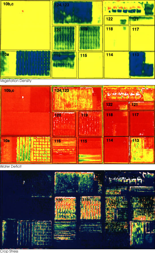
Across Moravia's cereal-growing belt, the gap between a uniform nitrogen plan and a field's actual nutritional needs can amount to tens of thousands of crowns per growing season. Soil electrical conductivity (EC) sensors, mounted on a trailing frame behind a quad-bike, now let agronomists map that variability in an afternoon rather than waiting weeks for laboratory results from sampled cores.
How Ground EC Measurement Works
A pull-behind sensor — such as units derived from the Veris 3100 design — passes a low-frequency current through the soil via coulter electrodes. The instrument records two depths simultaneously: a shallow reading at around 30 cm and a deeper one reaching 90 cm. Clay content, moisture, and organic matter all affect conductivity, so the resulting map reflects the soil's physical make-up rather than its chemical composition directly.
That distinction matters. EC maps are not fertiliser prescriptions. They are zone maps — they tell an agronomist where the field is uniform and where it splits into distinct management areas. Soil sampling can then be targeted one core per zone rather than one per hectare, cutting laboratory costs while improving zonal accuracy.
Nitrate Sensor Arrays in Moravia
Several cooperatives in South Moravia have trialled ion-selective electrode (ISE) probes, permanently installed at four depths in sentinel plots. The probes transmit hourly readings via LoRaWAN to a field management platform, flagging moments when nitrate in the root zone exceeds a threshold associated with leaching risk.
Results reported during the 2025 winter wheat season showed a 14 kg/ha reduction in applied nitrogen without yield penalty on the sandy-loam fields around Hustopeče. On heavier clay soils near Znojmo, the timing signal mattered more than the rate reduction — splitting the top-dressing application two days earlier than the standard calendar saved roughly 0.3 t/ha of the expected yield that would have been lost to late nitrogen stress.

Variable-Rate Application Equipment
Having a management zone map is only half the equation. Executing variable-rate fertilisation requires a spreader or sprayer fitted with section control and a GPS receiver accurate to at least 30 cm. Most machines currently operating on Czech farms meet that standard via EGNOS-corrected GPS; RTK receivers capable of 2 cm accuracy are becoming more common on new purchases but are not yet universal.
Spreading Accuracy and Headland Management
The headland — the strip at the field edge where the machine turns — traditionally receives double or triple the intended fertiliser dose due to overlapping runs. Section control valves that shut off individual boom segments as the machine crosses into an already-treated area can reduce this overlap to under 2% of the field area, compared with 8–12% on fields worked without GPS guidance.
For granular fertiliser spreaders, the challenge is disc-speed adjustment. Changing the spinner RPM alters both the application rate and the throwing pattern width. Modern ISOBUS-connected spreaders accept rate maps from a task controller and adjust disc speed in real time, but calibration data must be entered correctly for each product batch.
Data Integration and Farm Management Software
Czech cooperatives and larger individual holdings increasingly use platforms such as FarmSoft or German-developed systems like xarvio FIELD MANAGER to bring sensor data, yield maps, and prescription layers into a single interface. The practical barrier remains interoperability: not all sensor manufacturers use open ISOXML formats, and some proprietary systems add a subscription cost on top of hardware investment.
The Czech Precision Agriculture Association (Agronavigace) has worked since 2018 to establish recommended data formats for domestic farm management software. Progress has been gradual, but the pressure from EU digital farming policies — particularly the requirements of the new CAP's eco-schemes — has pushed more vendors toward compatibility.
Cost Considerations for Czech Farm Scale
The economic case for soil sensor investment varies with farm size. An EC mapping survey covering 200 hectares typically costs between 4 000 and 8 000 CZK including equipment hire and data processing. On a farm of that size, recovering that cost through nitrogen savings alone requires a measurable reduction in applied product — usually achievable in the first season on fields with high EC variability.
For farms below 80 hectares, the calculation is less straightforward. Shared-service models, where a contractor with mapping equipment covers several farms across a district in a single pass, have grown in the Vysočina Region and South Bohemia. District agricultural offices have subsidised trial programmes in several areas under the Rural Development Programme.